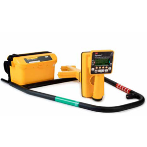
 Designed to be more accurate, faster and more integrated than any other locator on the market, the 3M™ Dynatel™ 2500 Series Locators and fault finders represent an advancement in locating and fault finding technology for the field professional. Offering a broad feature set with advanced digital processing, the 2500 Series locators combine simple interfaces with precision locating capabilities. All 2500 series locators offer six active frequencies and a maximum transmitter output of 12 watts providing a solution for virtually all challenging applications encountered in the field.
As with all 3M™ Dynatel™ Locator products, the 2500 series provides accurate pipe, cable or Sonde depth measurements, giving a digital readout in feet and inches, or centimeters (user-selectable). Lightweight, compact and well-balanced, these cable and pipe locators allow you to accurately and easily locate your underground plant and assets. The 3M™ Dynatel™ 2550-iD and 2573-iD have the additional capability to locate all standard electronic markers and to write, read and lock programmed information into 3M™ Electronic Marker System iD Markers. All 2500 series locators and fault finders are also compatible with select GPS/GIS field mapping instruments for real time mapping of electronic markers or pipe and cable facilities. Other user friendly features include the ability to enable or disable receiver frequencies and the ability to select audio sounds in the simple menu driven interface.
Product Features
• Trace view mapping display mode
• 6 active frequencies for direct connect
• 4 induction frequencies with maximum allowed output power
• All frequency mode in direct connect – 4 simultaneously
• Automatic impedance matching
• Ohm meter with high voltage detection
• Rugged, industrial temperature range
• 240VAC output protection
• Standard alkaline (c-cell) batteries
• Rechargeable battery kit
New to the world features in the 3M™ Dynatel™ Locators 2500 series include the trace view mapping interface that provides an intuitive mapping display showing the utility path combined with a precision peak antenna based antenna array to provide the utmost confidence in utility location.